
This website lets you monitor the water level in Marikina, San Mateo
As the southwest monsoon brought heavy rainfall, Clark Young, a software engineer who lives in Nangka, was kept up all night worried about the flood—especially since they live near the river.
In Marikina, there's an alarm system for the Marikina River, depending on its height above sea level. At 10:08 p.m. on July 21, the Marikina River water level reached third alarm, or 18 meters, which means forced evacuation for those in affected areas. According to a 24 Oras report, 1,637 individuals, or 346 families, were evacuated.
Since Young was up all night monitoring the water level, he created an easier way to get updates apart from the Marikina PIO Facebook page: BantayBaha, a comprehensive new flood monitoring platform with data from the Philippine Atmospheric, Geophysical and Astronomical Services Administration.
"What I found is there's already accurate data from the PAGASA flood monitoring website, but it's not really user-friendly, so I reverse-engineered their website and decided to create a simple flood monitoring website from their data," Young wrote in a Facebook post.
"I saw the water level [on the PAGASA website], and that [gave] me an idea. I tried to see the code because in the browser, you can inspect the code and see where the data is coming," he told PhilSTAR L!fe.
With that, he and Elbert Molina, his friend and fellow software engineer, created BantayBaha, which he shared on Reddit and Facebook.
"In our local government, there is already an update on the water level, but sometimes, it's taking too long, and when it's midnight, they don't really update. It is also hard to notice if the water is rising or going down; that's why the website really helps them to visualize the water level," Young shared.
How does BantayBaha work?
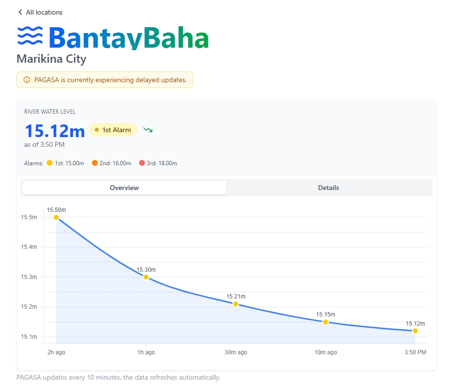
On the website, there is a real-time update on the river water level, as well as its corresponding alarm levels. The data also refreshes automatically as PAGASA updates every 10 minutes.
It's very simple to use. Just click or tap on the location you want to check. In Overview, there's a line chart showing the changes in water level over time. Another tab includes details of how many meters the water level has gone up or down.
The app is easily accessible on a mobile device with any browser, as Young made sure to make its user interface mobile-friendly.
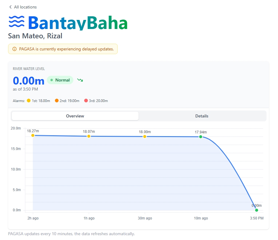
Currently, there are only two locations available on the website: Marikina and San Mateo.
Young plans to include Caloocan City, Pasig City, Makati City, the Tullahan River, and Mandaluyong City, as well as create a mini social media group to raise awareness about the flooded areas across the country.
"We're planning to have a social media group, so that we can post flooded areas, with photos and locations, or floodways, so other people can be notified if they are going to the area," he said, noting that certain areas have different alarm levels.
Aside from that, Young is eyeing including a forecast for water trend and tabs for emergency hotlines and numbers. He wants to partner with local government units to secure funding to improve the website's services."
He also aims to transform this website into a more accessible app so more people could benefit from it.
"This is something that I really want to have, [for] myself, because this also solved my own problem," he told L!fe.
"I really wanted to know as [a Marikenyo] if there is a chance to get flooded in the next two hours, or maybe we can see if we can go back to our home safely without worrying about the river, but it requires a lot of data, and hopefully we can partner with LGUs."
The National Disaster Risk Reduction and Management Council said on Tuesday, June 22, that six people were reported dead brought by the habagat and tropical cyclone Crising.
Five people were reported injured, and six others remain missing.
NDRRMC also noted that heavy rains had damaged approximately 1,500 houses and affected around 362,000 families, or approximately 1.2 million individuals.
